A phone connected to a cell tower in downtown San Diego at 9:47 PM. The tower serves a 0.4-square-mile area. Your client’s attorney wants you to say the phone was at a specific restaurant on Fifth Avenue.
You can’t say that. And if you try, opposing counsel will dismantle you.
Cell tower location evidence is real, useful, and regularly misunderstood by attorneys, clients, and — sometimes — examiners who should know better. Here’s what cell tower records can actually establish, what they can’t, and how to present them credibly in litigation.
What Cell Tower Records Are
When a mobile device connects to a cellular network — for a call, a text, or data — the carrier logs which cell tower (and which sector of that tower) handled the connection. These records are called Call Detail Records (CDRs).
CDRs typically contain:
- The phone number involved
- The date and time of the call/text/data session
- The duration
- The tower ID (often called the BTS ID or Cell ID)
- The sector (which direction the antenna faces)
- Occasionally, signal strength data (RSSI or similar)
Carriers retain CDR data for varying periods. Most major US carriers retain voice and SMS CDRs for 1-2 years. Data session records retention varies — sometimes shorter. When you need CDRs for litigation, time is always a factor. Preservation requests to carriers should go out immediately.

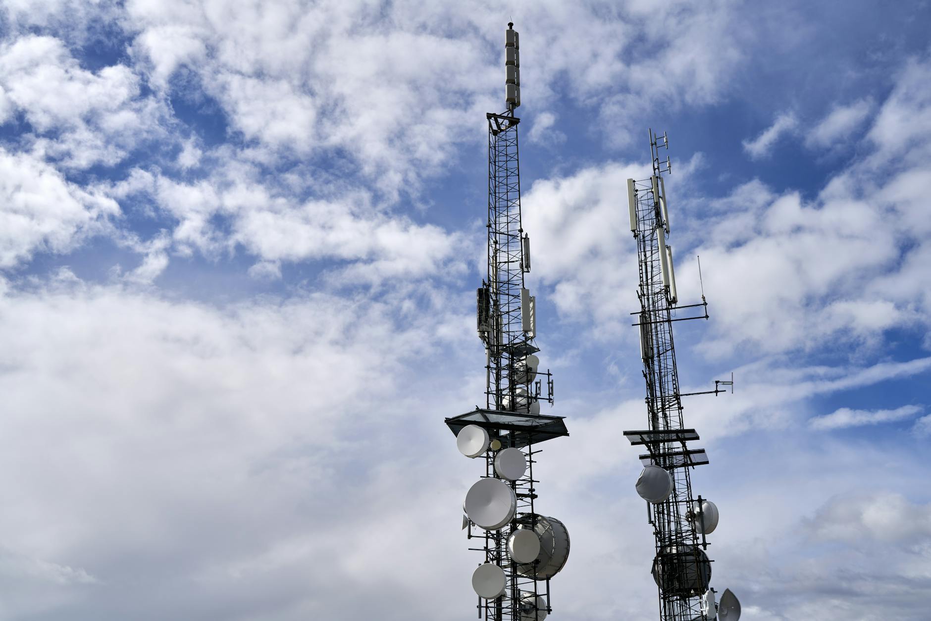
How Cell Towers Work: The Basic Physics
A cell tower isn’t a single antenna pointing in all directions. It’s a collection of sector antennas, typically arranged in three sectors of approximately 120 degrees each. Some towers have six sectors (60 degrees each) in dense urban environments.
Each sector covers a wedge-shaped area in a specific compass direction. When a phone connects to a tower, the CDR records not just the tower but the specific sector — telling you both which tower and which directional slice of that tower’s coverage area.
Coverage area size depends on:
Environment type. Urban towers serve small, dense coverage areas — sometimes as little as a few hundred meters in radius. Rural towers cover much larger areas — miles of radius in some cases — because there are fewer towers spread across more geography.
Tower loading. Carriers add towers where existing towers are overloaded. High-density areas have overlapping coverage from multiple towers, which reduces each tower’s effective coverage area.
Terrain. Hills, valleys, and buildings all affect signal propagation. A tower’s listed coverage area is theoretical; actual coverage is irregular.
Device behavior. A phone doesn’t always connect to the nearest tower. It connects to the tower with the best signal, which may be influenced by interference, load balancing, or momentary signal fading.
This last point is important in court: a phone connecting to a tower doesn’t necessarily mean the device was in the theoretical center of that tower’s coverage. The device was somewhere in the coverage sector, but precisely where in that sector is unknowable from the CDR alone.
What You Can Prove With CDRs
Let’s be direct about what CDR analysis can establish as evidence:
“The device was somewhere within the coverage area of this tower sector.”
That’s the core statement. Specific to the tower, specific to the sector (direction), and bounded by the coverage area. Not a point on a map — an area.
Pattern of life. Multiple CDRs over time reveal which towers a phone routinely connects to. This establishes general geographic patterns — the device regularly connects to towers in the Hillcrest neighborhood of San Diego, for example. Pattern-of-life analysis is stronger than any single data point.
Ruling out presence. CDRs can sometimes rule out presence at a specific location. If the device was connecting to a tower in La Jolla at 10:00 PM, it almost certainly was not in Chula Vista at 10:00 PM. The exclusionary use of CDR evidence is often more defensible than the inclusionary use.
Corroboration of other evidence. CDRs work best when they corroborate other location evidence — GPS data from an app, a surveillance camera, a bank transaction. On their own, they’re a geographic bracket. Combined with other evidence, that bracket narrows.
Carpenter v. United States (2018): The Constitutional Framework
The Supreme Court’s 2018 decision in Carpenter v. United States, 138 S. Ct. 2206, fundamentally changed the constitutional framework for cell tower evidence.
Timothy Carpenter was convicted of robbery based in part on 127 days of CSLI (Cell Site Location Information) that the government obtained from his carrier using a court order under the Stored Communications Act — which requires only “specific and articulable facts” rather than probable cause.
The Supreme Court held (5-4) that accessing CSLI requires a warrant based on probable cause under the Fourth Amendment. The Court recognized that long-term CSLI tracking reveals intimate details about a person’s life — “familial, political, professional, religious, and sexual associations” — in a way the third-party doctrine shouldn’t automatically expose to government surveillance without a warrant.
What Carpenter means for civil cases:
Carpenter was a Fourth Amendment case — it constrains government (law enforcement) access to CSLI, not private party civil subpoenas. In civil litigation, the framework for CDR access is the Stored Communications Act, and civil subpoenas can still reach CDRs without a warrant.
But Carpenter has had ripple effects: it signals judicial awareness that CSLI is sensitive location data, and some courts have applied heightened scrutiny to civil discovery requests for extensive CSLI data. When pursuing CDRs in civil matters, the scope of your request should be proportionate to the issues in the case.
Expert testimony post-Carpenter:
Defense attorneys in criminal cases have used Carpenter to challenge CDR-based expert testimony, arguing that the methodology of placing a defendant at a location based on CSLI is less reliable than prosecutors suggest. These challenges have had mixed success, but they’ve forced examiners to sharpen their methodology and accuracy claims. Civil examiners should expect similar challenges and be prepared to defend the statistical basis for any coverage area claims.
Coverage Maps and Their Limitations
When presenting CDR evidence, you’ll typically use carrier-provided coverage maps or third-party mapping tools to visualize tower locations and coverage areas.
Carrier coverage maps are often theoretically based — they show what the network is engineered to cover, not what devices in a specific case actually experienced. They’re a starting point, not a definitive boundary.
Drive testing (physically driving through an area with test equipment measuring signal from specific towers) produces empirically measured coverage data for specific towers. This is more defensible than theoretical maps but requires resources and time. In high-stakes cases where CDR evidence is central, drive testing creates much stronger foundation for coverage area testimony.
Third-party tools like Google Maps cell tower overlays, CellMapper, or commercial products provide community-sourced or modeled coverage data. These tools can be useful for visualization but should be disclosed as approximate models, not measured ground truth.
The key rule: always characterize coverage area evidence with appropriate uncertainty ranges. “The device was in the downtown San Diego area” is defensible. “The device was within 0.2 miles of Fifth Avenue” is overclaiming unless you have drive-test data or strong corroboration.
Urban vs. Rural: Accuracy Differences
The difference in accuracy between urban and rural CDR analysis is stark enough to change how you frame conclusions.
Urban environments:
Dense tower deployment means small coverage areas. In downtown San Diego, towers may be 200-400 meters apart. A CDR placing a device on a specific tower sector may indicate presence within a few city blocks. Still not GPS precision, but meaningfully narrow.
Urban environments also have more towers with overlapping coverage. Sophisticated analysis can use multiple simultaneous connections or handoff patterns (the sequence of towers a device connects to as it moves) to further narrow location inference.
Rural environments:
A single tower may cover a 5-15 mile radius. A CDR placing a device on that tower tells you the device was somewhere in a circle that might cover hundreds of square miles. Rural CDR analysis frequently produces geographic ranges too broad to be useful for specific location claims.
When testifying about CDR evidence in rural cases, be explicit about coverage area size. A statement like “the device connected to a tower with a typical coverage radius of 8 miles” is accurate and honest. “The device was near [specific town]” might be true if that town is the only settlement in an 8-mile radius, but should be qualified.
Building a CDR Analysis for Litigation
The practical workflow for CDR-based location analysis in civil matters:
Step 1: Preservation request to carrier. Send immediately upon engagement. Specify the phone number, the date range (with buffer — request more than you think you need), and specify that you want CDRs with tower and sector information. Some carriers require subpoena; others respond to preservation requests first and then subpoena for production.
Step 2: Carrier subpoena. In civil matters, a properly issued subpoena to the carrier is the standard vehicle. Include a rider specifying the data fields you need: call/text/data records, tower ID, sector, lat/long of tower if available.
Step 3: Data processing. CDRs arrive as spreadsheets with carrier-specific codes for tower and sector. You need the carrier’s cell tower database (typically obtained from the carrier or public FCC databases) to convert tower IDs to geographic coordinates and sector directions.
Step 4: Mapping. Plot tower locations and sector coverage areas. Tools range from QGIS (open-source GIS software) to commercial mapping platforms designed for CDR analysis.
Step 5: Timeline integration. Integrate the CDR timeline with other evidence — device data, surveillance records, witness accounts. The value of CDR evidence multiplies when it’s corroborated.
Step 6: Report calibrated conclusions. Write conclusions that accurately reflect what the data shows. Use phrases like “consistent with presence in the area of” rather than “proves presence at.” This isn’t weakness — it’s accuracy, and accuracy is what holds up under cross-examination.
Combining CDRs With Device-Side Location Data
The most powerful location analysis combines carrier CDRs with device-side location data from a full file system extraction.
Device-side location data includes:
- The locationd database (cell tower + GPS + Wi-Fi positioning data, often with higher granularity than CDRs)
- App GPS coordinates (Google Maps, Uber, delivery apps, photo EXIF)
- Wi-Fi network association logs (which networks the device connected to)
- Significant locations (iOS maintains a database of frequently visited locations)
When device-side GPS data places a phone at 32.7157° N, 117.1611° W at 9:47 PM, and the CDR simultaneously shows connection to a tower whose coverage area includes that exact coordinate, the two sources mutually reinforce each other.
CDRs without device-side data: a geographic bracket.
CDRs with device-side GPS data: potentially a precise location.
For any case where location is a material issue, the examination strategy should pursue both device extraction (see iPhone logical vs. full file system acquisition) and carrier CDRs in parallel.
FAQ
Q: Carriers say they don’t retain data connection records for as long as voice/SMS. What data connection records are actually available?
This varies by carrier and continues to change. As of 2026, major US carriers typically retain voice CDRs and SMS metadata for 1-2 years. Data session records (which tower handled a data session, when, and for how long) may be retained for shorter periods — sometimes as little as 90 days at some carriers. Tower ping data from some carriers is retained differently from call-specific data. When in doubt, serve your preservation request immediately and ask the carrier specifically what they retain and for how long. Don’t assume.
Q: Can a phone connect to a tower in one sector and actually be behind the tower in a different direction?
Yes. Cell tower signal propagation doesn’t perfectly respect sector boundaries. Physical obstructions, signal reflection, and variable antenna radiation patterns mean a device can sometimes connect to a sector that doesn’t theoretically cover its actual location. This is more common in dense urban environments where signal bouncing off buildings is significant. Experienced CDR analysts acknowledge this possibility and factor it into uncertainty ranges. It’s one reason coverage area testimony should be expressed as probabilistic, not definitive.
Q: How should I handle CDR evidence when the defendant’s phone showed connections to multiple towers within minutes?
Rapid tower switching indicates the device was moving (handoff as it traveled between coverage areas) or was in an area of overlapping coverage (the device may have been stationary but switched towers due to signal variation). In civil matters, rapid switching patterns can be analyzed to infer movement direction and speed, though this analysis requires expertise and clear explanation. Always present the raw tower sequence alongside any movement inference, and disclose the methodology for any movement analysis.
Q: Are there cases where CDR evidence has been successfully challenged and excluded?
Yes, though more commonly in criminal than civil cases. Challenges typically focus on: inaccurate coverage area claims (expert overclaimed precision), failure to account for the possibility of tower selection anomalies, or methodological gaps in how the expert derived their conclusions. The leading methodological critique is often that experts present CDR evidence as placing a device at a specific location when it can only place it within an area. Staying on the right side of that distinction — expressing conclusions in terms of geographic areas rather than specific addresses — is the primary defense against exclusion motions.